What is a hardiness zone?
A hardiness zone, also called "planting zone, growing zone or gardening zone", is a mapped resource for growers that defines the average extreme low temperatures for various regions. Growers use this information to choose plants that are best suited to their climate.
Tip: Knowing your zone helps you to choose what perennial plants to grow, since those plants come back every year and need to survive the cold, dark winter months.
How many hardiness zones are there?
There are 13 hardiness zones across Canada and the United States. Roughly moving north to south, each zone represents approximately 5.5° C or 10°F difference in average extreme low temperature.
The United States Department of Agriculture (USDA) used more than 30 years of historical low temperatures to determine each zone.
Remember these are average extreme lows, not the coldest it's ever been. In Canada, only nine of the growing zones fall within the country's border. So where a palm tree will thrive in a place like Florida, it wouldn't last a winter anywhere in Canada.
What zone am I in?
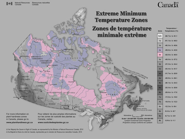
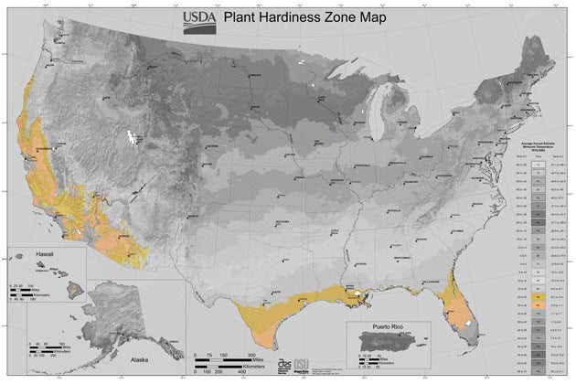
To find out what hardiness zone you're in, take a look at the maps below. These maps are available online from Natural Resources Canada and the United States Department of Agriculture. We'll share links to both at the end of the article.
Micro-climates
Once you figure out your growing zone, see if you're in a micro-climate within that zone. A micro-climate is a zone within a zone that has its own high and low temperatures. It could be because that area lies within a valley, sheltered by mountains. Or perhaps it's covered in rock, which absorbs the sunlight and heats up the surface temperature.
Did you know? You have your own micro-climates in your yard. That's why some plants grow better in one area of your yard than others.

Hardiness zone maps
The hardiness zone maps that you'll see here won't give you much information besides the average extreme lows for the zone. So once you figure out what zone you're in, search the internet to discover what grows best in your zone.
Zone 1

People living in this zone are no stranger to extreme temperatures. Stretching from Alaska, the Yukon and across the North West Territories into Nunavut. This region sees the mercury drop to -51.1°C (-60 °F) during the coldest months.
Last frost comes about late May and first frost is usually by the first of September.
Zone 2
Hardiness zone 2 covers most Provinces and Territories across the northern parts of Canada. Temperatures in this zone can hit a chilly -45.6°C (-50°F).
Last frost is mid May and first frost comes the first week of September.
Zone 3

Average extreme low temperatures in this zone can get as low -40°C (-40°F) in the winter. In Canada, the border provinces all have a band sitting in this zone.

In the United States, large parts of Alaska, Idaho, Montana, North Dakota, Minnesota and Wisconsin are in zone 3. The zone stretches down into Wyoming and even parts of Colorado. On the east coast, some folks living in the northern parts of New York, Vermont and Maine may find themselves in zone 3.
This zone has a limited growing season. Last frost is typically mid May and and by mid September you can expect first frost.
Zone 4

The average extreme low in zone 4 is -34.4°C (-30°F). The southern parts of Alberta, Saskatchewan and Manitoba are in this zone. Along with Canadians living on the north shores of Lake Superior and lake Huron. Moving east into Quebec, zone 4 runs north of the Ottawa River and moves along the north shore of the St. Lawrence right to the coast. Parts of New Brunswick and Newfoundland have a band in zone 4.

In the United States, zone 4 stretches from the Northwest into the Central Rockies and back up to the northern parts of the Midwest.
Last frost is usually Mid May and first frost comes by the 1st of October.
Zone 5

It usually doesn't drop below -28.9°C (-20°F) in zone 5. Large parts of Ontario are in this zone from Sudbury to the GTA and east along the north shore of Lake Ontario. The zone covers the southern part of Quebec along the US border and into southern New Brunswick.

In the US, 32 states have areas in zone 5. The zone stretches from the North East right across the Midwest, butting up against the eastern side of the Rockies.
Last frost is usually around mid May and first frost comes midway through October.
Zone 6

The temperature tends to stay above -23.3°C (-10°F) in zone 6. People living in Nova Scotia, southern Ontario and parts of British Columbia experience this kind of weather.

In the US, zone 6 starts on the east coast and goes right across the center of the country. It touches 38 states before it hits the Rockies and runs north, not quite making it to the west coast.
Last frost happens about the 1st of April and first frost comes around the middle to late October.
Zone 7

People living in this zone rarely see temperatures dip below -17.8°C (0°F). If you're a Canadian, head west right to the coast of Victoria Island, BC.
On the east coast, folks living in New Jersey, Delaware, Virginia, North Carolina are in this zone. The zone also covers parts of Georgia, Alabama, Tennessee, Mississippi, Arkansas, Oklahoma and north Texas. At New Mexico, the zone starts to breakup into smaller pockets as it heads north into the Rocky Mountain States.
Last frost usually happens around the middle of April while first frost typically comes by the first week in November.

Zone 8

Last frost usually happens late in March and first frost comes about the third week in October.

Zone 9
The average low temperature in zone 9 is -6.7°C (20°F). Victoria, BC as well as coastal areas of Vancouver Island are in zone 9.
In the United States, a small strip along the coast in Oregon, much of California and Arizona fall into zone 9. Same with the southern part of Texas and into Louisiana. There's also a wide band right through the center of Florida.
Last frost is typically no later than March 1 and first frost doesn't come until mid December.
Zone 10

If you're living in Los Angeles, CA, the southernmost tip of Texas or the Florida Everglades, you're in zone 10. Temperatures only get as low as -1.5°C (30°F). It's hard to find conclusive information about first and last frost in zone 10. Possibly because the zone rarely if ever gets cold enough!
Zone 11

The temperature in parts of Hawaii's interior usually stays above 4.5°C (40°F) as well as a small area in Puerto Rico.
Zone 12 / Zone 13

The coast of Hawaii and the interior of Puerto Rico see a low average temperature of 10°C (50°F) . While coastal area temperatures of Puerto Rico stay above 15.5°C (60°F).
Did you find this article helpful?
If so, stick around and learn about soil fertility in this eye opening post.
Further reading
Visit the Natural Resources Canada website to access and download hardiness zone maps.
Visit the United States Department of Agriculture website to access a detailed interactive hardiness zones map.